“Analyze the urban form of your hometown,”
the paper assignment read.
I was in the last semester of college on the opposite side of the country, enrolled in a course called Designing the American City. In my four years as a student, I hadn’t spent much time back in Stockton—between study abroad programs and summer internships, there were too many other places to live. Yet just before it was to launch me, diploma in hand, toward an entirely new terrain, my liberal arts education first chose to rein me in, back to the city that raised me (and I assume many of you, too).
It is rare to meet someone on the East Coast who knows much about Stockton. It’s becoming more common now—between our Forbes infamy and our dubious distinction of being the largest American city to have ever filed for bankruptcy, thorough readers of the New York Times National section have by now read our city’s name. For other Easterners, basic knowledge of NorCal geography does not extend further than San Francisco (occasionally Sacramento). After a few years of achieving little headway after explaining my origins, I took to identifying Stockton as a place mentioned in The Grapes of Wrath. (I think Steinbeck isn’t assigned as much in high school anymore.)
“You’re from Stockton? I think I drove through there once. Yeah… my sister played at a soccer tournament in Stockton when I was, like, six. Our car windows were smashed in.”
For the past 30 years, our city has been an integral waypoint on both Interstate 5 and Highway 99, the main paths between the northern and southern parts of California. Within a state that is defined by its car culture, this strategic location has brought many benefits (mostly economic); Stockton’s inland port remains busy despite the flagging economy, and our county’s agricultural products easily find their way into supermarkets around the world. It also means that, if you’re one of the 38 million residents of California (or one of the 25 million annual passengers on I-5), chances are good that you will have to drive through Stockton at one point or another.
In a compendium of essays describing each of the 50 states, the novelist William T. Vollman (a Sacramento transplant) is given a few thousand words to describe California. The “California dream,” he writes, was first of “an island of Amazons,” then of a golden promised land, and most recently of a tropical, self-sufficient paradise, has always been in tension with the mundane reality of life here. But this is most visible from our roads:
Drive on; so much more of California than I can tell you is about driving nowadays! You can roll from Los Angeles north to Sacramento on Interstate 5 (which, as a matter of fact, runs all the way from Mexico to Canada), seeing not much else but dry mountains, flat fields, and urban sprawl, glittering monster trucks and shining four-doors rolling down wide ways between narrow green strips. This route exaggerates the ruination of my home state. From the freeway it is especially easy to believe that, say, Stockton stretches hideously east and west like the worst of Los Angeles.
Vollman’s take on Stockton is clear: it is a place on the path to bigger and more beautiful points, a symbol of post-industrial sprawl. Rather than beckoning visitors with a pastoral landscape, the view repels passers-by. Stockton, for him, is an eyesore that is impossible to ignore.
Drive past the liquor stores on Charter Way or the foreclosed homes on Thornton Road or the shuttered factories east of Oak Park and it’s obvious that something went wrong with our urban development. This isn’t a new observation. David Garcia of the Stockton City Limits blog, the developer Dan Cort, and the Campaign for Common Ground have advocated for smart growth for years, and scholars like Dr. Dawn Bohulano Mabalon have recorded some of the social impacts of Stockton’s poor urban planning (i.e. the destruction of “Little Manila” and broader marginalization of minorities in our region). There are countless sons and daughters of Stockton who remember the impact these changes had on the vibrant, messy, denser Stockton of the 1950s, and how it became the city we inhabit today. My term paper, which now finds its way into this collaborative magazine for and of Stockton, aims to illuminate one aspect of this story: a history of our roads and railroads, in particular I-5. How have our transportation thoroughfares influenced our city’s growth, our reputation in California, and complex problems of economic and social stratification?
In the middle of the 20th century, Stockton’s urban planners had much different aspirations for the image they would project to drivers on the proposed Interstate 5. Empowered by the first opportunity to shift the major transportation routes into the area in decades, they led the interstate along the city’s western border and into its upscale suburbs (present-day Lincoln Village, Brookside, and Spanos Park), with the aim of impressing visiting travelers. Already coping with the decline of Stockton’s downtown, they aimed to highlight the more pleasant, attractive, and modern residential areas on the city’s outskirts. Stockton’s policymakers used the routing of I-5 to project a more flattering, positive image of the city to passers-by and use north Stockton to spur development throughout the city, but they failed; instead, their choice of I-5’s route helped exacerbate ongoing trends toward unsightly and unsustainable low-density residential development. They hoped to improve the face of Stockton seen from the windows of cars traveling on I-5, but instead damaged it further.
State Highways and Stockton “slums”
Stockton has always been imagined as a transportation hub. Founded amidst the chaos of the 1849 gold rush, Stockton’s original city fathers (let’s be real: women’s voices were not included in those pre-Suffrage days) imagined it would be a profitable center to link the mining areas of the eastern foothills, the agricultural Central Valley, and the sea-facing Bay Area. The first U.S. settlers of Stockton—led by a German-born pioneer by the name of Charles Weber—structured Stockton in what was by then a typical frontier pattern: the Jeffersonian grid. Imitating nearby San Francisco (and more distantly, cities on the eastern seaboard like New Haven, Philadelphia, and Savannah), streets were arranged in a “rectilinear” fashion, with the center of the city being the port at the mouth of the inland delta [see Appendix A, label #3]. The design, with its 90° intersections and straight boulevards, was not novel, but it was practical: it allowed for quick development and easy regulation, and settlers flocked from the East Coast, Asia, and Latin America.
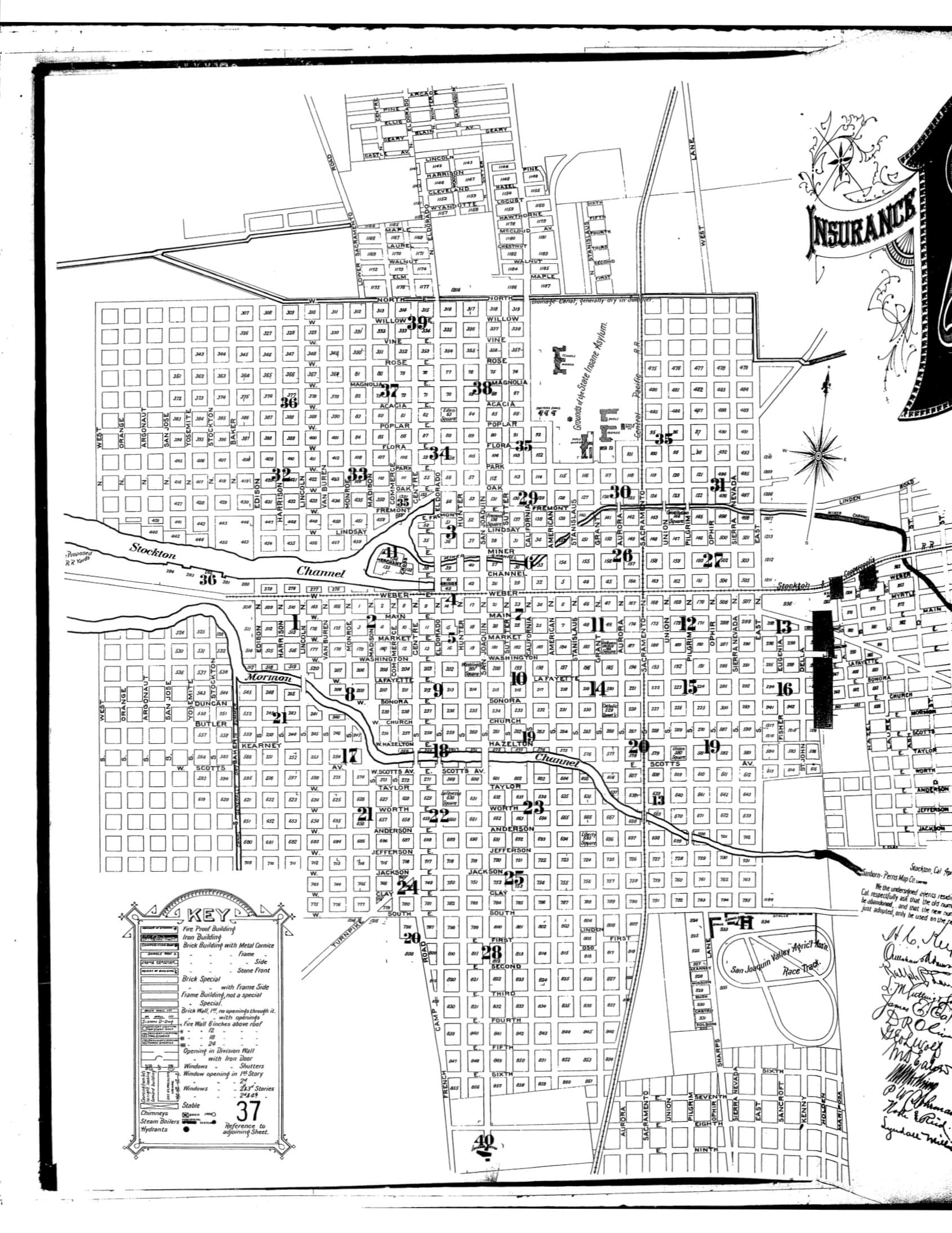
For the first decades of its existence, Stockton grew at a steady but slow pace. As an 1895 fire insurance map shows [Appendix A], Stockton at the end of the 19th century was a moderately-sized California city with a population of 20,000 people—almost half the size of Los Angeles. But located on a deep inland channel and surrounded by an easy, flat terrain, Stockton soon attracted both gold-hungry miners and industrialists hoping to capitalize on a dearth of infrastructure. The first transportation links to the external world came with the construction of Stockton’s two major railroads: the Central Pacific and Stockton & Copperopolis lines. Fueled by the influx of wealth garnered by the gold boom, railroads developed rapidly into the heart of the city, where they remain largely unchanged until today—trains to and from San Francisco came along Taylor Street (where today’s Amtrak station stands, south of Hazelton and Scotts) and a north-south railroad took the place of Sacramento Street (today, the ACE Train station anchors this railway).
As immigration in California picked up pace around the turn of the 20th century, population in Stockton boomed, but from early on the railroads created pockets of racialized development. The historian Olive Davis notes that north of city hall, in the areas around Oak Park and Dameron Hospital, “subdivisions cropped up in every direction” and that property sold “for as little as 1/48th down payment, ‘three dollars down and three dollars a month.’” But this open, cheap land was not available to all. Stockton realtors, like those in many other contemporary towns, established restrictive racial covenants in which they agreed not to sell property in northern neighborhoods to Asian, Latino, and Black buyers. City government helped in this fight: Stockton city ordinances in the early 1900s mandated that Chinese settlers, for example, could only build their homes south of City Hall. Non-white Stocktonians established their communities in the west and south, hugging the railroad tracks. These areas were named “Skid Road,” (later “Skid Row”). The Depression, and then the economic recovery sparked by WWII brought a large influx of domestic-born and foreign-born immigrants, and Skid Row boomed.
The story gets a little more complicated when the automobile comes into play. With the advent of the car, Stockton became an important part in a nation-wide rush to build roads. California began investing in a modest state highway system as early as 1903, and by 1913, the (privately-funded) transcontinental Lincoln Highway linked Stockton by car to the Pacific Ocean and to the rest of the country in the east [see Appendix B].

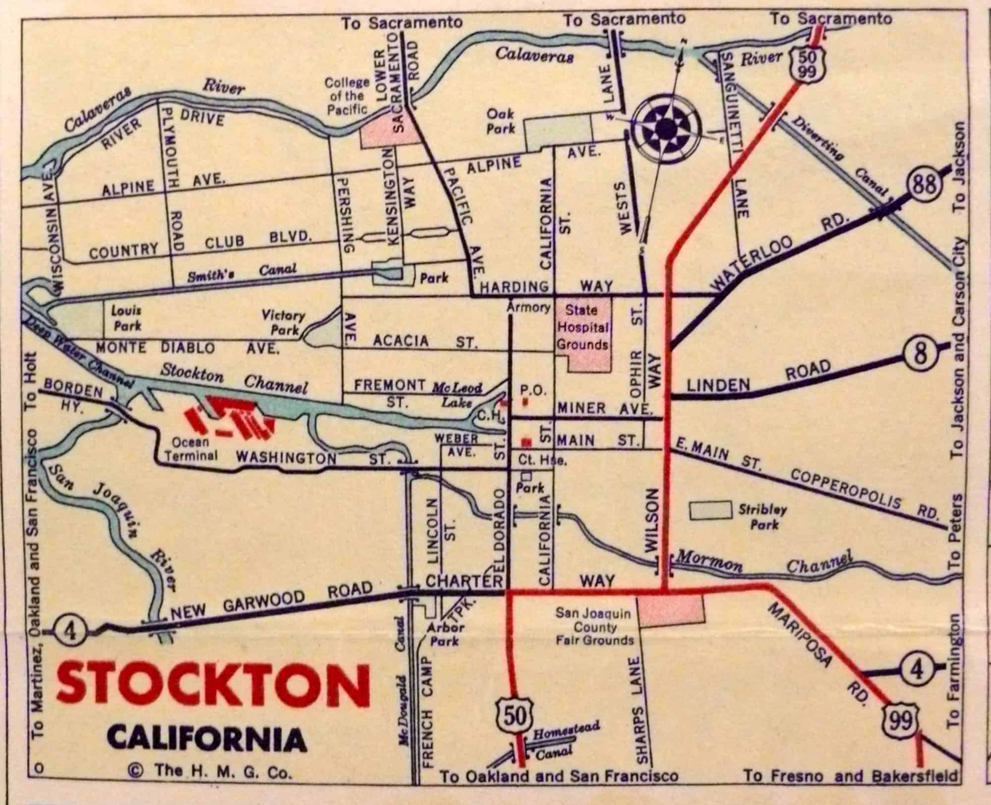
Presumably because it was the easiest, cheapest path, the Lincoln Highway was built on the east edge of Stockton, where Wilson Way stands today [labeled in red on Appendix A; route shown in 1941 on Appendix C]. This later became State Route 99/State Route 50, which led from the Mexico border through Stockton almost one thousand miles north to the border with Oregon.
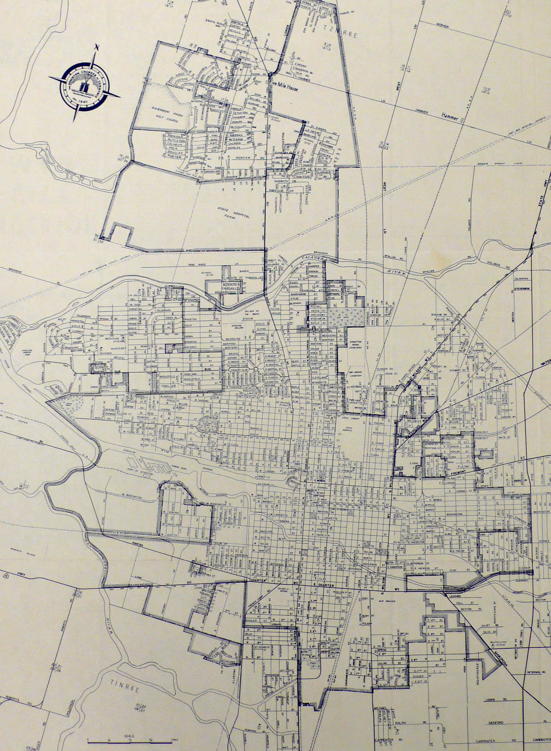
Yet through WWII and into the 1950s, the city of Stockton continued to grow. Because land in California was cheap and plentiful, the city mirrored other cities in the Central Valley and Southern California—and grew outwards. City policymakers played a deliberate role in this, supporting expansion into the emerging northern residential suburbs, the most popular of which was Lincoln Village. Appendices E and F, maps of the Stockton city limits in 1943 and 1950 (respectively), illustrate the major growth that occurred north of the Calaveras River in the span of just seven years. In 1943, nothing north of the present-day University of the Pacific was listed on the map; by 1950, whole acres of residential communities had appeared. Lincoln Village was originally built outside of the Stockton city limits, but the city council was eager to bring them into urban jurisdiction, annexing these communities within the first five years of their construction. (A reminder that Lincoln Village was not originally part of Stockton: many of the homes around Lincoln High do not vote in city elections and fall outside the boundaries of the Stockton Police Department.)
Sprawl to the north fed into itself: in return for annexation rights, the City Council promised protective policies for developers, and from the beginning of the 1950s, the Stockton City Council supported zoning measures to protect residential areas on the north side while opening land in the south to “unrestricted use.” Despite housing values steadily rising in the northern neighborhoods, land values stalled in the southern parts—exacerbated by the fact that all public low-income housing after 1960 were built south of the Calaveras River.
By 1960, many citizens of Stockton had abandoned the historical center, and south/west Stockton became home only to the “poor and ethnic minorities.” The city government gave preferential treatment to the low-density (White) suburbs in the north while abandoning the (Black/Latino/Asian) urban centers in the south and west. But while the city’s governmental focus had shifted northward, the major transportation corridors remained centered in the south and west, where ‘slums’ had developed on both sides of State Route 99.
I-5 and Selecting a ‘See Stockton’ Drive
While the rest of the city’s design changed rapidly between 1920 and 1970, transportation changes arrived more slowly. Urban designers like Robert Moses were fantasizing about expressways in New York beginning in the ‘30s, but it was not until the passage of 1956’s Federal-Aid Highway Act that Stockton’s city policymakers gained an opportunity to update the city’s infrastructure. Throughout the 1960s, the Stockton City Council and San Joaquin County Board of Supervisors were asked to give feedback on a proposed federally-funded highway, what would eventually become I-5. The state authority in charge of planning the new interstate proposed two options: renovating the old Highway 99 as a wider, higher-capacity interstate or constructing an entirely new highway on the western side of the San Joaquin Valley, paralleling SR99’s route.
The state authority preferred the western path because of simple arithmetic: building a new highway west of Lincoln Village was cheaper and quicker. But within Stockton, policy makers revolved around other rationale: Stockton’s reputation. They hoped that a new interstate on the west side of town would allow them to change the image projected to drivers passing through. “There had always been beautiful homes on tree-shaded streets in town but travelers never saw them,” writes the historian Davis. “They saw instead the slums along Highway 99 and the old rundown areas in south Stockton.” City policymakers and economic leaders had long bemoaned the problem of the image presented to travelers on SR99, and in addition to aesthetics, they worried that they were missing opportunities to highlight the business promise of Stockton’s port. The Chamber of Commerce had since the end of WWII attempted to market Stockton’s inland port as a major asset to its economy, but still it lagged behind other, more visible ports in the Bay Area. While Stockton aimed to be the “Distribution Center of California,” few knew of its economic infrastructure.
By 1970 the highway authority had chosen to build the Stockton I-5 segment along the western city limits, bisecting the still-developing northern suburbs. City leaders were, for the most part, pleased. Writing in 1984, Davis claims:
The opening of the final leg of the freeway [I-5] probably did more to improve the city’s image than any other event in its history…When the I-5 bridge was constructed across Stockton Channel travelers were treated to a panoramic view of the city, including an impressive overview of the port… Construction in the north end of the city was spurred on with the completion of I-5.
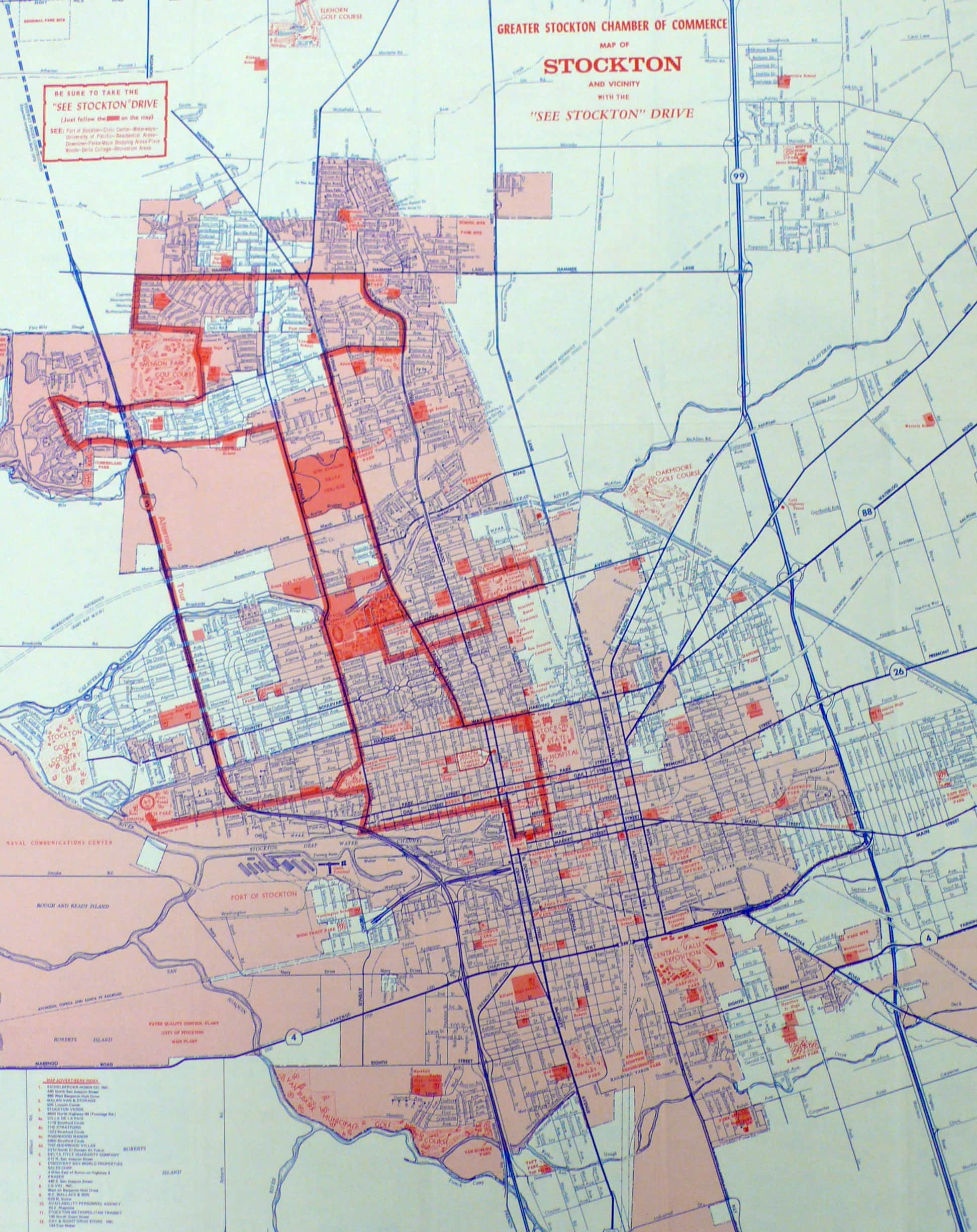
Materials from the Chamber of Commerce corroborate this claim. In the 1973 promotional map of Stockton, the Chamber identifies a “See Stockton” Drive, much of which follows I-5 into northern Stockton [see Appendix F]. More than half of the driving tour lie north of the 1943 city limits—indicative of how much the center of power had gravitated northward. Stockton’s business community was eager to highlight the suburban, residential areas along I-5 in the north, thinking that they offered a better image than the ‘slums’ of South Stockton.
It is relatively easy to piece together the rest of the story since the 1970s; Stockton continued to expand further and further north, each time abandoning the neighborhoods that had previously been considered ‘respectable.’ As overt racial restrictions disappeared, Stockton’s downtown neighborhoods did not magically become integrated—those Asian and Latino and Black residents that could afford to move fled northward; the rest stayed behind. Low-cost, low-density, single-family homes proliferated, and Stockton saw little need to incentivize high-density or public housing in the city—putting a strain on city services (for example fire and police were forced to protect much larger areas). In recent times, this has been related to Stockton’s title as the foreclosure capital of the world. During the economic boom of the early 2000s, the houses built along I-5 in the north allowed greater numbers of families to own their homes, but now many sit empty. Meanwhile, Stockton’s neighborhoods remain fragmented, divided into ‘good’ and ‘bad.’ As of the 2010 census, we remain one of most segregated metro areas in the county for Hispanics and Asians, and our ubiquitous gated communities foster isolation and distrust between our neighborhoods. Thanks to I-5, it is possible for the average resident of north Stockton to avoid ever driving down a surface street in the south side; the same goes for residents of the historic downtown and southern areas.
Stockton’s Future: Car Culture Reconsidered
I-5 is now our city’s backbone; it is our connection to the rest of the country and the world and perhaps the only reason our population has continued to grow despite the housing crisis and recession. It is also a huge part of our city’s problem. In embracing interstate highways (and a car-friendly, expansive development model), Stockton’s city planners hoped to reposition us in the 1950s as a forward-thinking, progressive, new kind of town. Unfortunately, these choices have wrought havoc on our civic cohesion.
In the next 20 years, the population of Stockton is projected to as much as double. Cities must adapt or perish, and Stockton will need to update its roads and rails. One must wonder whether infrastructure changes in the next two decades will have unintended consequences like the establishment of I-5.
While it is impossible to project into the future with certainty, some models suggest that the mere presence of freeways serves to destabilize the Central Valley region: not only from the perspective of economic viability but also from angle of land-use. Choosing to invest in interstates and wide roads has already harmed Stockton’s civic life, and it may soon endanger one of our few remaining industries: agriculture. If the current trends of suburban sprawl continue, we may run out of arable land.
There is hope: shifting away from an automobile-focused urban plan (such as the model advanced by proponents of high speed rail) may help to alleviate these challenges in the long run. I look forward to the day when I can board a train in downtown Stockton and be in San Francisco in an hour or Los Angeles in two. Downtown Stockton is experiencing a resurgence, thanks to local entrepreneurs who see potential in our area’s beautiful historic buildings. We have miles of bike paths, on the Calaveras River levees and even down North California Street into downtown Stockton; but we need to construct many more miles, and we need them to be interconnected. Against the backdrop of our city’s major economic woes, infrastructure investments seem impossible, but choosing to avoid these investments may incur greater costs in the future.
I’m not under any delusions: if we replaced our eight-lane highways with bike lanes and mass transit and rebuilt Stockton to be a walkable, compact city, our city would still have sizeable challenges. This article does not advocate for tearing down our biggest thoroughfare; it instead seeks to recognize how Stockton’s city leaders have tackled the tricky issues of urban planning over the last half century, and propose changes in our thinking that would mitigate some of our city’s social issues.
Hey, it might even prove that college papers can sometimes be useful. What a thought.